
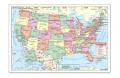
Essential to any classroomClear, concise images are based on digital cartography. Bright colors on laminated paper are ideal for teaching and classroom use. U.S. Rolled Map delineates all state lines and capital cities, with insets of Alaska and Hawaii. Also displays Mercator projections of longitudes and latitudes. Comes rolled in its own hard fiber tube. Is suitable for tacking to corkboard or clipping to blackboard. May be wiped clean with damp cloth. Overall dimensions: 40W x 28"L

